 |
|||
 |
|||
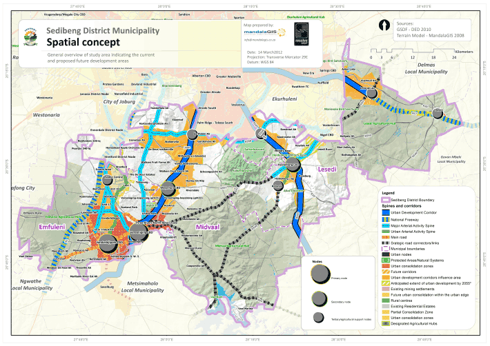
| 7. The Spatial Development Framework (SDF) 7.1 The cornerstone of an effective GDS is a deep and thorough understanding of provincial endowments and assets, development potential and constraints, along with the forces shaping these and how they are changing over time. These should be spatially referenced, with the trend information being specifically important. The SDF provides the spatial information with regard to development potential and growth areas that will give effect to the implementation of the GDS. The institutional arrangements and resource requirements to meet the challenges must be identified in the GDS, appreciating that some of the resources and capacities required, may reside in other government spheres. This should inform the difficult choices around resource allocation, usage and trade-offs (in the interests of maximising developmental impact). The SDF is one of the main tools which is utilised, to ensure the eventual realization of the spatial vision and spatial objectives of the GDS2 and the Integrated Development Plan of the municipality. It is a key legislative mechanism to address the numerous developmental challenges of the District. A number of these challenges considered and interpreted by the SDF include:
7.2 In order to achieve the above spatial development objectives, the Sedibeng District Municipality proposes to manage spatial development in a manner that will focus on existing strengths and development opportunities, whilst addressing areas of critical need. Conceptually, this approach is labelled as: Building on Urban and Rural Strengths In essence, the conceptual approach acknowledges that the urban areas of greater Lesedi, Emfuleni and Midvaal and environs, are likely to be the focal points for significant economic growth and development within Sedibeng District over an extended period of time. However, it is accepted that there is a dependency amongst a significant proportion of the residents of Sedibeng District on access to peri-urban and/or rural land for basic livelihood (i.e. survival or subsistence) purposes, and that this is likely to continue to be so, at least in the medium term (10 years). Therefore, it is concluded that: 7.3 The proposed Spatial Development Framework consists of various structuring elements, such as nodes, corridors and the open space network. These proposed developments are constrained and will have to be phased in accordance with the availability of engineering services and funding for key infrastructure. Due to the constraints with infrastructure four approaches are proposed, namely:
7.3.1 Nodes and Development Corridors A hierarchy of nodes have been identified. At the District scale, two Primary Development Nodes are identified:
In addition, three Secondary Development Nodes are proposed:
Finally, additional Tertiary Development Nodes are proposed to function as local service centres and to support the agricultural sector.
Development corridors are development areas that are situated adjacent to transport routes, and thus do not have a specific boundary. Mixed use development is encouraged in these areas as the road infrastructure provides visibility and accessibility, infrastructure and opportunities for public transport infrastructure . Three such corridors have been identified, namely: a | Along the R59 between Meyerton and Vereeniging The R59 and the rail line that runs adjacent to it, forms a natural opportunity for a corridor. In fact, previous studies have recognized it for this potential. However, because of the underlying geology and relative remoteness from the largest population concentrations in the area we would recommend that it only enjoy partial development. The sitting of industrial activities, which are incompatible with residential land uses, would be ideal. Generally speaking, the best opportunities lie to the west of the R59, especially when one considers the industry type that is recommended. The existing local road running to the west of the R59 is ideally situated to serve as a frontage road and provide direct access to potential development sites. b | N17 Freeway The N17 Freeway is located within the northern section of the Lesedi Local Municipality and creates a link between Gauteng and Mpumalanga Province. Although the R29 Road (between Endicott AH and Devon) runs parallel to the N17, the distance between these roads is too far to provide an effective development corridor. It is proposed that development nodes be established at the intersection of the R42/N17 and R550/N17. These development nodes could act as catalysts for the development of Endicott/ Vischkuil and Impumelelo / Devon. c | N3 Freeway The development focus along the N3 freeway should be a combination of Nodal development and corridor development in order to maximize investment opportunities. The existing accesses and entrances to the N3 with the R23, R42 and the R550 should be strengthened by nodal development. Apart from the frontage (visual impact) along the N3 between the respective nodal areas which should be utilized (subject to available areas) for “clean” service industries, the development strip between the N3 and the R103 presents the ideal opportunity for the establishment mixed land uses, with the focus on industries, office parks and manufacturing. This area could become the new locality for investors, which are dependent on the Gauteng/Kwazulu Natal and Free State link. 7.3.2 Environmentally Sensitive Areas The principle is to ensure sustainable development into the future where natural resources are protected for future generations. In order to promote a healthy environment to live and work in, a well-defined open space network is required where conservation-worthy or sensitive natural features require protection. The following zones are proposed for rehabilitation and protection:
Preferred outcomes in this element include managed land use practices (where limited development appropriate to the environment could be permitted) and the demarcation of restricted conservation areas. These areas will add value to the area, not only as natural resources, but will function as tourist and recreational spaces for the community. 7.3.3 Human Settlements These settlements should be differentiated into areas where planning has progressed sufficiently to confirm an area's status as a Settlement Zone, and areas where such planning is still required (termed Potential Settlement Zones)
7.3.4 Mobility and Accessibility Although some of the major roads provide opportunities for development and thus have been classified as development zones, the region requires linkages and roads where the main function of the road will remain to increase mobility and accessibility. Mixed use high density development should be promoted along selected stretches of these corridors, in support of the public transport function and to extend economic activity into the township areas. (a) Moshoeshoe Road Specific attention should be given to the proposed east-west linkages throughout the district, especially the routes to the north. These routes will create better accessibility and connectivity to the region. The north-south R82 route is particularly relevant as it currently has the status of a mobility spine, but it is envisaged that it needs to become a development corridor in the future.
The key spatial projects do not constitute a full list of all interventions and developments that will be undertaken in the area. It rather highlights those priority interventions with either the highest catalytic impact, highest legacy value, or which are critical to the future growth of the area. These projects can also be depicted in relation to the spatial development and does not include the policy and regulatory interventions required. All the projects are not necessarily public sector initiatives, but may require government support and facilitation to the private sector. Some of them are identified as key flagship projects of GDS2, but all of them are critical for implementation through the IDPs:
7.5 The strategy for spatial development cannot on its own ensure the success of the implementation of the SDF. The spatial strategy is supported by various other strategies and programmes which is part of a co-ordinated and integrated package to ensure that investments and programmes form the basis of longer-term growth and development and that it supports a proper hierarchy of settlements. It also requires that there must be a certain level of intervention with decision-making and implementation to ensure a deliberate move towards a more functional and optimal spatial pattern for the municipality, also creating sustainable settlements. The extent in which financial and institutional resources are mobilised, will undoubtedly have a major impact and could result in a meaningful change in the existing spatial pattern towards a more natural settlement pattern for the future. A very high level of co-ordination and joint prioritisation is required with respect to all these strategies to ensure support of the geographic locations of the agreed to macro spatial plan. Minimum requirements for service provision to all communities must exist, but priority settlements must be identified for better levels of services to create the economic threshold, which is required for sustainable development. |
|||
| Growth and Development Strategy | Sedibeng District Municipality © 2012 | |||